
BLUE RIVER VALLEY: PHASE 1, DISCOVERY RESULTS
PROJECT DESCRIPTION
Spanning more than 4,600 acres, stretching from I-435 and the Truman Sports Complex on the south to the confluence of the Blue and the Missouri Rivers in the north, the Blue River Industrial District was once the city’s economic engine (home to major employers like Armco Steel, Ford, GM) and known for being an affordable outdoor recreation getaway for Kansas Citians. Unfortunately, after years of disinvestment and despite best intentions, no single united vision has taken root.
For more than 30 years, Kansas City, Missouri has faced a challenge: How to make the best use of the Blue River Industrial Corridor. This project began a six-month Discovery process to learn how best to answer that question with a holistic and comprehensive strategy that looks at the Blue River Valley through three key lenses: Industry, Nature, and Community.
Investment Theses
1. Determine catalytic interventions as acupuncture points.
2. Lift up existing companies and underutilized sites.
3. Recruit companies with the best technology of the day to live, work, and play in BRV.
4. Unify bespoke projects with a common narrative to guide development patterns.
5. Remove policy obstacles that have impacted the implementation of approved plans.
Goals
1. Reclaim the innovative spirit of the place whose model leads the country.
2. Integrate and optimize for health balancing industry, community, and nature.
3. Create generational wealth by design and governance for all strata of society; particularly stimulating upward mobility for communities of concern.
Future phases of this project are forthcoming and will focus on the implementation of proposed projects.
PROJECT DATA
Location
Kansas City, Missouri
Document Links
Plan Documents located HERE
Year
2021 - 2022
Client
Industrial Development Authority
Kansas City Economic Development Corporation
Team
Hoxie Collective
Foundation for Regeneration
Parson & Associates
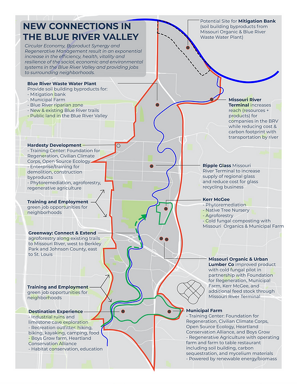
The diagram to the right identifies key sites and connections throughout the Blue River Valley that are ripe to host regenerative economic development projects and programs.

There are 1654 businesses and a workforce of over 10,000 people who commute to work in the Blue River Valley each day. Only 400 both live and work within the boundary. Jobs in the corridor are primarily in Manufacturing which accounts for almost 3,000 jobs (28%) with the second highest industry as Wholesale Trade with 2,500 jobs (24%). Nearly 69.3% of folks in the Blue River Valley have graduated high school (8.2% college). Currently, there is an unemployment rate of 12.8%. During our Discovery Process, we met with and presented to BVIA members, created a directory of businesses in the Blue River Valley, and sent out both a survey and interactive GIS tool to collect historical points, problems/issues, and project ideas.

The Blue River Valley area is home to 6 residential neighborhoods and over 13,000 residents (ACS 2015 - 2019): North Blue Ridge, Sheffield, Blue Valley, Dunbar, Vineyard Estates, and Eastwood Hills. The total population of the area currently reflects a low point. Peaking in the 1950’s with just over 20,000 residents, the population has been declining ever since and is projected to continue to decline. The median age of a community member is 31.6 years old with 74% people of color (either hispanic or black). 31% of the population are children and 9% are seniors. The obesity rate is 44%. The rate of population loss is projected to slow in the coming years, but currently, it is estimated that another 1,000 residents will leave the corridor by 2050. With this decrease in population, vacant housing has increased from 400 units in the 1970s to 1,400 in the most recent census. The median home value is $43k and the majority were built before 1950.

The Blue River Valley is a tributary to the Missouri River that was once a major tourism draw for
outdoor recreation like fishing and canoeing with amenities like houseboats and restaurants. While these activities are few and far between now, the Blue River Valley still has nearly 2000 acres of parks and tremendous potential to become a destination again; all while encouraging healthier lifestyles, mitigating flood risk, sequestering carbon, and beautifying our City. The Blue River was studied by Heartland Conservation Alliance in their Blue River Report Card. In the most recent iteration of that report, the lower Blue River was given an overall grade of D, with the lowest grades coming from the categories of Collaborative Governance and Native Habitat. The full river was given a C-.
The Blue River Valley’s ground cover is currently 34% trees, 21% grass, and 32.5% impervious surfaces (buildings, roads, etc.). With a 47.8 Heat Wave Risk Score, this area is considered “Very High” and is estimated to lose $382k annually because of heat waves. During our Discovery process, the team kayaked the Blue River and learned from representatives at the Army Corps of Engineers, regenerative farmers, and several nature conservationists.